Sunday, June 30, 2013

Paul Bobby

The water flow on the White River was too high to wade/walk in. The river normally flows at a depth of a couple of feet and you can walk across the river easily. However, this was a bit unusual in that the Dam was producing power for the high load created by the heat.

A good thing did happen though, in that there are two other dams that hold back river water, and could be fished -- if the power company held back on producing.

We wanted to fish the White anyway and the only way to do it was to hire a guide and his boat. I hemmed and hawed a bit trying to find the right guide. In general, it can be a pig in a poke for quality.

We started looking and ultimately found Paul Bobby -- The GI on the Fly (ex Air Force MP)

Paul was an honest man and suggested that instead of hiring him for a full day and baking in the sun, he would suggest a half day and start that nearer to 3:00 than 12:00

So Paul picked us up at 3:00 and we started fishing around 3:30. The half day ended up in the dark! We didn't get back to the tent until about 9:30 -- and then the temperature was a comfortable 70ish.

Here we are at about 8:30 with the sun just starting to set.


The Forbes magazine article

Well it did call Mountain Home one of the top ten trout towns in the US. If you looked around you might agree.


Arkansas Bravado

Shout it out, WE ARE SECOND BEST!

And for those that remember the restaurant is NOT named AVIS


We didn't go. Why would we? We would prefer the world's #1 restaurant.

Arkansas Antique

Yup

This is what is called a "cell-phone" in Arkansas

Enter the little cell and make a call.

That is, if the thing still works and if you know how to use it

Do these things take dimes or quarters?

Wednesday, June 26, 2013

web spinner

 A look at the work of some bugs -- dew in the AM


Next Stop - Mountain Home Arkansas

Yes, we are in Arkansas. Why? because there is very good trout fishing in the tailwater sections of a couple of north central Arkansas.

Mountain Home was listed as a premier fishing town in an article at Forbes magazine. Since it was "on the way" to Montana, we decided to stop for a few days and fish the White and North Fork Rivers.

While it was cool and comfortable in Asheville, Arkansas is a different story. It is in the low 90's and should continue in that range until we leave after 5 days. The good news is that their is very little humidity.

With the water temperature in the river at about 55F or so, it is easy to stay cool and get comfortable.  The difference temperature between the river and the surroundings creates some interesting fog conditions on the river at the beginning and ends of the day.

The White River is what is called a big river, in that it is wide and can be full of water. Since the river is controlled by a dam and the dam is subject to water releases to generate power, the water level can fluctuate a lot and put our type of fishing (wading) in the "chancy" category.

Country Lanes

After 911, all streets needed a real address, so that emergency vehicles could find places.  As a results, simple lanes now needed to have names.

When you drive around in many parts of the country you get to see what happened.

What you see is:

Bullman St.
Peter Bullman St.
John Bullman St.
Mikes St.
Babes Ln
Loyd St
John Kea St.

Just lots of streets that have been obviously names after the owner.

Alicia and I were wondering if someone new bought the house (usually the only house on the "street") could that rename it for themselves?

Sunday, June 23, 2013

What to do on a rainy day?

Go fishing!

We decided to fish over in east Tennessee, at the South Holston river. The "SoHo" is regarded one of best fisheries in Tennessee, and is prized by all the Orvis guys who work in nearby Roanoke -- well, it's well worth the drive.

We had been there a few days ago and caught lots of fish. The Soho is a tailwater, meaning that it is below a dam. In this case the South Holston Dam, part of the Tennessee Valley Association  (TVA). They generate power at the dam and, as necessary, release a LOT of water to do so. As a result, you have to be rather careful to observe the river for signs of rising water. TVA also notifies everyone ahead of time with a big siren, so you just have to pay attention or you're in for a big swim in fast moving water. We watched it rise 2 feet in 30 minutes.

So, on this day (Tuesday, June 18) at the SoHo, we left Marshall early so as to not challenge the 1:00pm release.  It was overcast here ... when we got there, it was raining on and off, more on than off.  Well what to do after you just drove 90 minutes to go fishing, and it's pouring rain --- you go fishing!

It was raining and foggy on the river ...


 It remained rainy and foggy at the river ...


Around 12:30, it started to rain really hard. So with the release coming in about 30 minutes, we decided to leave. But it was pouring out and we were still suited up for fishing. We normally just take off our fishing stuff at the car -- but it was POURING!

So we packed into the car with the wet clothes on and looked for either sun (no chance) or some place to get out of the wet stuff.

What better place than at a do-it-yourself car wash --- heck, nobody was using it!  And it was fully covered.


Tuesday, June 18, 2013

A bit of the Blue Ridge Parkway

Well there has been some interesting weather here in Asheville: quite a bit of rain, lots of fog, clouds and morning dew, and some rain. All in all, the total sum of weather has been partly cloudy with chance of rain.

Anyway, we did have one nice morning (this past Saturday ... with friends Robin and Paul) and we were able to set out and get onto the Blue Ridge Parkway while the weather was fair. We focused on getting to Craggy Gardens near Mt. Mitchell. Mitchell is the highest peak east of the Mississippi at 6630Ft.  It's called Craggy Gardens because of the Rhododendrons there.


View looking west.


View looking West.


Monday, June 17, 2013

Asheville - Part 3 the scene

We toured downtown Asheville and came away with the following impressions:
--Thanks to Robin and Paul!
  • Feels a lot like Cambridge, but more interesting, more compact.
  • The downtown area is mostly restaurants and small stores, not big bank buildings.
  • TONS of music, in bars as well as on the street corners
  • Lots of people milling about the downtown area
  • The Friday night drum circle, in a park in the middle of town, is crazy
  • It feels a lot like a hippy city
  • Tons of breweries and brewpubs
  • Most of the people in town were young.
Buskers were everywhere. Busker


The Grand Arcade -- an older building that was recently gentrified


 Sister Saurkraut is a fixture in town and a part of the Comedy City Tour
LaZoom  - likely coming to your town soon.


These two buskers were live statues - drop a $1 in the white guys bucket and he started to play -- like a jukebox - donate to the indian looking lady and she curtsies.


Asheville Part 2 - the view

We actually have friends in Asheville - a woman who used to work for Alicia and her husband. We got together with them and they gave us a tour of the city.

Asheville is situated in a valley and sits low among the many different hills and mountains in the general vicinity of the Blue Ridge Mountains.  We have yet to see the mountains in clear skies. What we see is clouds, haze, rain, etc... wonder when it becomes clear.

Here is a view from a mountain side fancy hotel.


Alicia enjoyed the decadence


Sunday, June 16, 2013

Asheville, NC

So, why go to Asheville, -- because it is in the mountains, it has good fishing, it is a very rapidly developing new-hippy community. Also, we have not been to the Smokey Mtn area, or for that matter, western NC. So with a view to a new place, we focused on Asheville.

How we got here is also an interesting story. We were up in Camp Liberty, the Maine place of a friend of ours, and her nephew shows up.  We told him our plans and has says that his dad has a place in Asheville --- and we should stay there! So, with some communications, we ended up staying in his Dad's place. Well, actually his dad is an old friend and a former tenant of ours when we owned the 2-family in Belmont. So, we kind of fell into a nice place in the mountains of the Asheville area -- Marshall, NC  to be exact.

Here is the view from Ed's porch.


Road to Ed's place - -up the hill


Saturday, June 15, 2013

A view of the New

Alicia likes staying at nice B&Bs, .. well I do too.

The is the view from our porch at the Inn at Riverbend, in Pearisburg VA.


Blue RIdge Parkway

We had intended to drive a good portion of the Blue Ridge Parkway, but didn't as a result of inclement weather -- rain and fog.

The rain and fog did not make viewing the scenery all that interesting.  We only saw lots of green, lots of trees, but no vistas

Here's what we saw:


Doors

This is not about the 70's Rock band --- but just some interesting entries

Looks like a door to a lawyer's office

Not a lawyer's office

Friday, June 14, 2013

A fight over a beautiful bridge

The Antietam battlefield is just outside of Sharpsburg MD. The battle there lasted one day and ended up being the most costly in terms of troops. Of all of the Civil War battles, it cost the most lives, more than the 3-day battle of Gettysburg.

One famous situation was the skirmish at the Burnside Bridge. The bridge is very pretty, but that day there were 5700 Union troops opposed by 500 Confederate troops. They were all stacked up on both sides of the bridge -- the Confederate troops had the advantage of holding the high ground. After 3 hours, the Union broke through.


Looking from the Union side to the hill that the Confederates commanded.

Thursday, June 13, 2013

Sharpsburg MD

As we move around we are staying in B&Bs. This approach gets us into some quaint locations. We stayed in Sharpsburg, MD last Saturday night and that offered a number of good photo opportunities.

This is Main St.

Main Street Sharpsburg.

I like the way porches are right off the sidewalk


A study of peeling paint


The Antietam plaque on houses that existed during the battle there

Wednesday, June 12, 2013

An Oxymoron?

You decide.


Holy Moly

We drove through Emmittsburg, MD --  which is what I was told a "very Catholic" town. Lots of stuff, but mostly it was the home of the only American saint -- Elizabeth Seton. It is also the place of a replica of Our Lady of Lourdes.  It seem that one could get cured here. My mother probably should have visited Emmittsburg.

We didn't stop to look for the holy water but did see the well named espresso shop.


Gettysburg

We finally visited Gettysburg (this past Saturday).

I have been interested in this Civil War battlefield even since I read Killing Angels, the Pulitzer Prize winning historical novel that told the tale of the battle.

killing angels - highly recommended

Gettysburg was, together with Vicksburg, a significant turning point in the Civil War.  It was the most northern penetration of the North by Robert E. Lee. After Gettysburg, the war was controlled by the Union and ended 2 years later.  Lincoln's Gettysburg address occurred after the battle as the country was trying to decide on how to bury the dead. The last images are from the National Cemetery that was created there.

a very detailed profile of the events of the day

The battle must have been crazy as it pitted 12,500 CSA (south) troops against an equal number of Union (north) troops. And, for the most part, was fought between Seminary ridge controlled by the CSA and Cemetery ridge controlled by the Union. Imagine being on a hill and looking across 1/2 mile of land and seeing 12, 500 men stretched over about a mile. The battlefield itself was mostly treeless farm land broken up by stone walls, a major road and crazy fences.  It remains today as it was then.

It is very hard to describe what happened there. Most people are familiar with Pickett's Charge, which although not totally correct in the overall scheme of things, was possibly the final break point that ended the 3 day battle.


to the left is Seminary ridge and way over on the right is Cemetery ridge. -- this is the battlefield.

Imagine looking from here and seeing 12.500 troops all lined up where the trees are.

The union side of the battlefield - Cemetery ridge.
Looking from the CSA side.


More from the south side.
Imagine running across the field and encountering these fences.


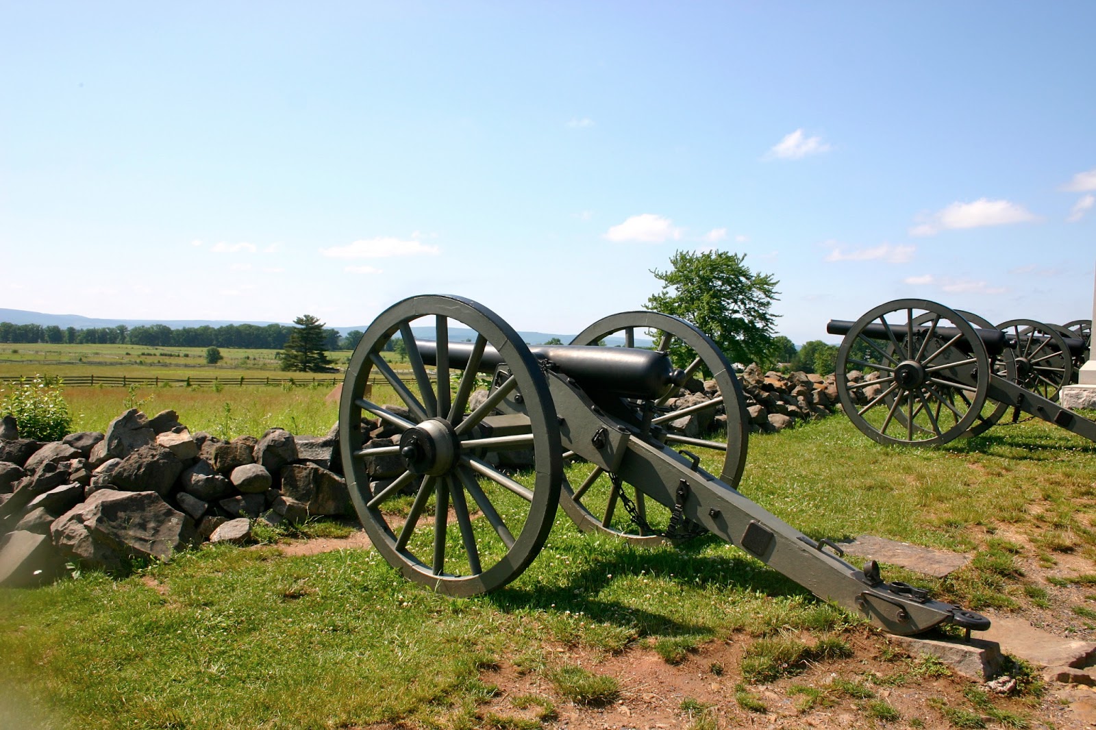
Limbers -- which holds all the cannon stuff.


 The aftermath -- many deaths - known and unknown. Large number of deaths over a period of 3 days, but not the most in a civil war battle.... that happened at Antietam.